Pays/Territoires
Mise à jour 2021-01-12 18:58:07
Les noms des pays/territoires du monde sont donnés en Français et Chinois. Cette collection des précieuses terres fermes du monde que toute l'humanité partage inclut non seulement les pays indépendants, mais aussi des régions spécifiques qui ne sont pas membre de l'ONUOrganisation des Nations Unies: Nous, peuples des Nations Unies ... Une ONU plus forte pour un monde meilleur. Veuillez aussi consulter les noms des pays en masculin et féminin en Français.
GéoPays Fermer
41
id
Pays
Pays en Anglais
Navassa Island
Pays
Ile Navassa
countryucasefr
ILE NAVASSA
Pays en Chinois
Pays en Espagnol
Isla De Navassa
Pays en Italien
Isola Di Navassa
Pays en Portugais
Console De Navassa
Pays en Allemand
Insel Navassa
countryfull
Navassa Island
countrynm
Navassa Island
ISO2
UMI5
ISO3
UMI5
countrycodeisono
581
countrycodeirs
BQ
countrycodeirsfr
BQ
countrycodeirsmixt
BQ
♀Féminin
17
7
57
1
currencypxcode
USD
Superficie km2
5,20
arealand
5,20
coastline
8
timezonedeltabegin
-5
flaglink
maplink
bq-map.gif
visapassenger
-1
rankincome
222
location
Caribbean, island in the Caribbean Sea, about one-fourth of the way from Haiti to Jamaica
terrain
raised coral and limestone plateau, flat to undulating; ringed by vertical white cliffs (9 to 15 m high)
naturalresources
guano
cooking
Caribbean, island in the Caribbean Sea, about one-fourth of the way from Haiti to Jamaica
9
rgbback
16777215
todate
1
42
id
Pays
Pays en Anglais
Netherlands Antilles
Pays
Antilles néerlandaises
countryucasefr
ANTILLES NEERLANDAISES
Pays en Chinois
Pays en Espagnol
Países Bajos Antillas
Pays en Italien
I Paesi Bassi Antille
Pays en Portugais
Países Baixos Antilhas
Pays en Allemand
Die Niederlande Antillen
countryfull
Netherlands Antilles
countrynm
Netherlands Antilles
ISO2
AN
ISO3
ANT
countrycodeisono
530
countrycodevehicle
NA
countrycodeolympic
AHO
countrycodeirs
NT
countrycodeirsfr
NT
countrycodeirsmixt
NT
♀Féminin
1
13
6
24
languagesfr
Néerlandais
74
currency
guilder (a.k.a. florin or gulden)
currencyfr
euro
currencyisocode
ANG
currencyisocodefull
ANG 532
currencypxcode
ANG
currencysymbol
Ant.f. or
currencysubdivision
100 cents
currencyregime
US-$ (1.79)
currencyvalue
0.5655
nationalityfr
Hollandaise
Capitale
Curaçao
capitalfr
Curaçao
Préfixe Tél.
599
Superficie km2
800
arealand
960
landarablerate
0.1
coastline
364
timezonedeltabegin
-4
flaglink
maplink
annew.gif
visapassenger
-1
largestcity
Curaçao
rankpopulation
176
Population
218 126
rankgni
144
gni
2510000000
rankincomeorigin
50
rankincome
53
income
11409
lifeexpectation
75.6
alphabetizationrate
0.98
natalityrate
0.01536
fecondity
2.06
mortalityrate
0.0064
mortalityrateinfantile
0.01037
growthrate
0.00855
nationalevent
Queen's Day (Birthday of Queen-Mother JULIANA in 1909 and accession to the throne of her oldest daughter BEATRIX in 1980)
nationaleventfr
Jour de la Reine (Anniversaire de la Reine Mère JULIANA en 1909)
nationalholiday
30 April
Date de naissance aaaa-mm-jj
2000-04-30 00:00:00
7
5
president
Reine BEATRIX des Pays Bas
location
Caribbean, two island groups in the Caribbean Sea - one includes Curacao and Bonaire north of Venezuela; the other is east of the Virgin Islands
terrain
generally hilly, volcanic interiors
naturalresources
phosphates (Curacao only), salt (Bonaire only)
9
rgbback
16777215
todate
1
43
id
Pays
Pays en Anglais
New Caledonia
Pays
Nouvelle-Calédonie
countryucasefr
NOUVELLE-CALEDONIE
Pays en Chinois
Pays en Espagnol
Caledonia Nuevo
Pays en Italien
Nuovo Caledonia
Pays en Portugais
Caledonia Novo
Pays en Allemand
Neues Caledonia
countrypy
xin1 ka1 li3 duo1 ni2 ya4
countrylocal
Nouvelle-Calédonie
countryfull
New Caledonia
countrynm
New Caledonia
ISO2
NC
ISO3
NCL
countrycodeisono
540
countrycodeirs
NC
countrycodeirsfr
NC
countrycodeirsmixt
NC
♀Féminin
18
6
57
languagesfr
Français
2
currency
franc
currencyfr
euro
currencyisocode
XPF
currencyisocodefull
XPF 953
currencypxcode
XPF
currencysymbol
CFPF (Comp
currencysubdivision
100 centimes
currencyregime
Euro (119.253)
currencyvalue
0.01025
nationalityfr
Française
Capitale
Nouméa
capitalfr
Nouméa
Préfixe Tél.
687
Superficie km2
19 060
arealand
18 575
areawater
485
landarablerate
0.0038
landforestrate
0.204
coastline
2254
summit
Mont Panié 1 682 m..
timezonedeltabegin
11
flaglink
maplink
nwcalmap.gif
outlinemaplink
grandmap.gif
visapassenger
-1
maincities
Dumbéa, Canala, Bourail, Thio, Hienghène, Houaïlu, Koumac, Kone
largestcity
Nouméa
rankpopulation
175
Population
225 000
rankgni
136
gni
3270000000
rankincomeorigin
37
rankincome
38
income
14864
lifeexpectation
73.78
alphabetizationrate
0.97
natalityrate
0.01898
fecondity
2.35
mortalityrate
0.00564
mortalityrateinfantile
0.00789
growthrate
0.01334
urbanization
0.75
nationalevent
Bastille Day
nationaleventfr
Jour de la prise de la Bastille
nationalholiday
14 July (1789)
Date de naissance aaaa-mm-jj
1789-07-14 00:00:00
6
10
location
Oceania, islands in the South Pacific Ocean, east of Australia
terrain
coastal plains with interior mountains
naturalresources
nickel, chrome, iron, cobalt, manganese, silver, g
2
Web
rgbback
16777215
todate
1
44
id
Pays
Pays en Anglais
Niue
Pays
Niue
countryucasefr
NIUE
Pays en Chinois
Pays en Espagnol
Niue
Pays en Italien
Niue
Pays en Portugais
Niue
Pays en Allemand
Niue
countryfull
Niue
countrynm
Niue
ISO2
NU
ISO3
NIU
countrycodeisono
570
countrycodeirs
NE
countrycodeirsfr
NE
countrycodeirsmixt
NE
♀Féminin
18
6
51
75
currency
dollar
currencyisocode
NZD
currencyisocodefull
NZD 554
currencypxcode
NZD
currencysymbol
NZ$
currencysubdivision
100 cents
currencyregime
float
currencyvalue
0.6966
Capitale
Alofi
capitalfr
Alofi
Préfixe Tél.
683
Superficie km2
260
arealand
260
landarablerate
0.1923
coastline
64
timezonedeltabegin
11
flaglink
maplink
nucolor.gif
outlinemaplink
nuout.gif
visapassenger
-1
largestcity
Alofi
rankpopulation
225
Population
2 124
rankincome
222
nationalevent
Waitangi Day (Treaty of Waitangi established British sovereignty over New Zealand)
nationaleventfr
Jour Waitangi
nationalholiday
6 February (1840)
Date de naissance aaaa-mm-jj
1840-02-06 00:00:00
7
1
location
Oceania, island in the South Pacific Ocean, east of Tonga
terrain
steep limestone cliffs along coast, central plateau
naturalresources
fish, arable land
9
rgbback
16777215
todate
1
45
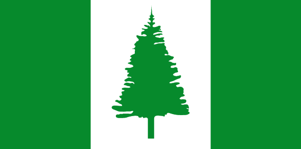
id
Pays
Pays en Anglais
Norfolk Island
Pays
Norfolk Island
countryucasefr
NORFOLK ISLAND
Pays en Chinois
Pays en Espagnol
Isla De Norfolk
Pays en Italien
Isola Della Norfolk
Pays en Portugais
Console De Norfolk
Pays en Allemand
NorfolkcInsel
countryfull
Norfolk Island
countrynm
Norfolk Island
ISO2
NF
ISO3
NFK
countrycodeisono
574
countrycodeirs
NF
countrycodeirsfr
NF
countrycodeirsmixt
NF
♀Féminin
12
6
51
10
currency
dollar
currencyisocode
AUD
currencyisocodefull
AUD 036
currencypxcode
AUD
currencysymbol
A$
currencysubdivision
100 cents
currencyregime
float
currencyvalue
0.7485
Capitale
Kingston
capitalfr
Kingston
Préfixe Tél.
672
Superficie km2
34,60
arealand
34,60
coastline
32
timezonedeltabegin
11.5
flaglink
maplink
norfolk.gif
outlinemaplink
nf.gif
visapassenger
-1
largestcity
Kingston
rankpopulation
227
Population
1 879
rankincome
222
nationalevent
Pitcairners Arrival Day
nationaleventfr
Jour d'Arrivée des Pitcairners
nationalholiday
8 June (1856)
Date de naissance aaaa-mm-jj
1856-06-08 00:00:00
3
5
location
Oceania, island in the South Pacific Ocean, east of Australia
terrain
volcanic formation with mostly rolling plains
naturalresources
fish
9
rgbback
16777215
todate
1
46
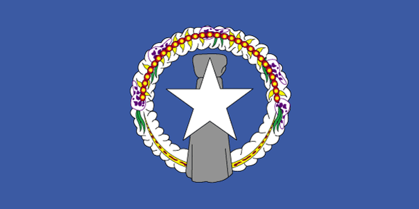
id
Pays
Pays en Anglais
Northern Mariana Islands
Pays
Mariannes (îles de)
countryucasefr
MARIANNES (ILES DE)
Pays en Chinois
Pays en Espagnol
Islas De Mariana Norteñas
Pays en Italien
Isole Di Mariana Del Nord
Pays en Portugais
Consoles De Mariana Do norte
Pays en Allemand
NordcMarianacInseln
countryfull
Northern Mariana Islands
countrynm
Northern Mariana Islands
ISO2
MP
ISO3
MNP
countrycodeisono
580
countrycodeirs
CQ
countrycodeirsfr
CQ
countrycodeirsmixt
CQ
♀Féminin
12
6
51
1
currencypxcode
USD
Capitale
Saipan
capitalfr
Saipan
Préfixe Tél.
1-670
Superficie km2
477
arealand
477
landarablerate
0.1522
landforestrate
0.304
coastline
1482
timezonedeltabegin
10
flaglink
maplink
nmarmap.gif
visapassenger
-1
largestcity
Saipan
rankpopulation
193
Population
76 000
rankincome
222
nationalevent
Commonwealth Day
nationaleventfr
Jour du Commonwealth
nationalholiday
8 January (1978)
Date de naissance aaaa-mm-jj
1978-01-08 00:00:00
4
6
location
Oceania, islands in the North Pacific Ocean, about three-quarters of the way from Hawaii to the Philippines
terrain
southern islands are limestone with level terraces and fringing coral reefs; northern islands are volcanic
naturalresources
arable land, fish
cooking
The islands, which include Saipan, Rota, Farallon de Pajaros and Tinian, total some 477 square kilometers. Saipan and Tinian have the best ports and harbors. Download high resolution version (992x496, 124 KB)Large flag of the Northern Mariana Islands. ... Image taken from www. ... Flag ratio: 1:2 The flag of the Northern Mariana Islands was adopted on July 4, 1976. ... A motto is a phrase or collection of words intended to describe the motivation or intention of a sociological grouping or organization. ... locator map for the Northern Marianas - made for Wikipedia File links The following pages link to this file: Northern Mariana Islands User:DanielZm/test Roman Catholic Diocese of Chalan Kanoa Categories: Country locator maps | Northern Mariana Islands | GFDL images ... As with any complex, emergent concept, language is somewhat resistant to definition. ... The English language is a West Germanic language that originates in England. ... Chamorro, or Chamoru, is the native language used in Guam and Northern Mariana Islands. ... Carolinian is an Austronesian language spoken in the Northern Mariana Islands, where it is an official language along with English and Chamorro. ... In politics a capital (also called capital city or political capital — although the latter phrase has an alternative meaning based on an alternative meaning of capital) is the principal city or town associated with its government. ... Saipan is the largest island and capital of the Northern Mariana Islands of the western Pacific Ocean, with a total area of 120 km² (46. ... A head of state or chief of state is the chief public representative of a nation-state, federation or commonwealth, whose role generally includes personifying the continuity and legitimacy of the state and exercising the political powers, functions and duties granted to the head of state in the countrys... List of Northern Mariana Islands Governors Carlos S. Camacho Democrat 1978-1982 Pedro P. Tenorio Republican 1982-1990 Lorenzo I. De Leon Guerrero Republican 1990-1994 Froilan C. Tenorio Democrat 1994-1998 Pedro P. Tenorio Republican 1998-2002 Juan N. Babauta Republican 2002- Categories: Lists of governors of U.S... Juan Nekai Babauta (born September 7, 1953, Tapanag, Saipan) is current governor of the Northern Mariana Islands. ... This article explains the meaning of area as a physical quantity. ... Here is a list of the countries of the world sorted by area. ... (Redirected from 1 E8 m2) To help compare different orders of magnitude and geographical regions, we list here areas between 100 km² and 1000 km². See also areas of other orders of magnitude. ... Square kilometre (US spelling: Square kilometer), symbol km², is an SI unit of surface area. ... In the most common sense of the word, a population is the collection of people—or organisms of a particular species—living in a given geographic area. ... Population density can be used as a measurement of any tangible item. ... This is a list of sovereign states and other territories by population. ... Independence is autonomous self-government of a country by its residents and indigenous population. ... The dollar is the name of the official currency in several countries, dependencies and other regions (see list below), including the US dollar, the worlds most widely circulated currency (see list below). ... -1... UTC also stands for the University of Tennessee at Chattanooga Coordinated Universal Time or UTC, also sometimes referred to as Zulu time, the basis for civil time, differs by an integral number of seconds from atomic time and a fractional number of seconds from UT1. ... The National Anthem is the name of a song by the band Radiohead. ... A top-level domain (TLD) is the last part of which Internet domain names consist of. ... .mp is the Internet country code top-level domain ( ccTLD) for Northern Mariana Islands. ... Saipan is the largest island and capital of the Northern Mariana Islands of the western Pacific Ocean, with a total area of 120 km² (46. ... Rota, also known as the peaceful island, is the southernmost island of the United States Commonwealth of the Northern Mariana Islands (CNMI). ... Farallon de Pajaros (from spanish Farallón de los pájaros, meaning Birds Rock), also known as Uracas (from Spanish Urracas, meaning Ravens), is the westernmost island in the Northern Mariana Islands chain. ... Tinian is one of the three principal islands of the Commonwealth of the Northern Marianas Islands. ... (Redirected from 1 E8 m2) To help compare different orders of magnitude and geographical regions, we list here areas between 100 km² and 1000 km². See also areas of other orders of magnitude. ...
9
rgbback
16777215
todate
1
47
id
Pays
Pays en Anglais
Palmyra Atoll
Pays
Atoll Palmyra
countryucasefr
ATOLL PALMYRA
Pays en Chinois
Pays en Espagnol
Palmyra Atoll
Pays en Italien
Palmyra Atoll
Pays en Portugais
Palmyra Atoll
Pays en Allemand
Palmyra Atoll
countryfull
Palmyra Atoll
countrynm
Palmyra Atoll
ISO2
UMI4
ISO3
UMI4
countrycodeisono
581
countrycodeirs
LQ
countrycodeirsfr
LQ
countrycodeirsmixt
LQ
♂Masulin
17
7
51
1
currencypxcode
USD
Superficie km2
12
arealand
11,90
coastline
14.5
timezonedeltabegin
-11
flaglink
maplink
lq-map.gif
visapassenger
-1
rankincome
222
location
Oceania, atoll in the North Pacific Ocean, about half way between Hawaii and American Samoa
terrain
very low
naturalresources
terrestrial and aquatic wildlife
cooking
Oceania, atoll in the North Pacific Ocean, about half way between Hawaii and American Samoa
9
rgbback
16777215
todate
1
48
id
Pays
Pays en Anglais
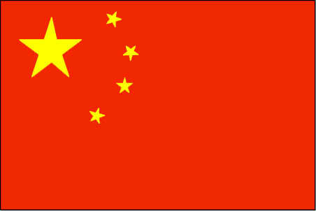
Paracel Islands
Pays
Iles Paracel
countryucasefr
ILES PARACEL
Pays en Chinois
Pays en Espagnol
Islas De Paracel
Pays en Italien
Isole Di Paracel
Pays en Portugais
Consoles De Paracel
Pays en Allemand
Inseln Paracel
countryfull
Paracel Islands
countrynm
Paracel Islands
ISO2
CHNP
ISO3
CHNP
countrycodeisono
156
countrycodeolympic
CHN
countrycodeirs
PF
countrycodeirsfr
PF
countrycodeirsmixt
PF
♀Féminin
5
1
126
3
Préfixe Tél.
86
coastline
518
timezonedeltabegin
8
flaglink
maplink
pf-map.gif
visapassenger
-1
rankincome
222
location
Southeastern Asia, group of small islands and reefs in the South China Sea, about one-third of the way from central Vietnam to the northern Philippines
terrain
mostly low and flat
naturalresources
none
cooking
Southeastern Asia, group of small islands and reefs in the South China Sea, about one-third of the way from central Vietnam to the northern Philippines
9
rgbback
16777215
todate
1
49
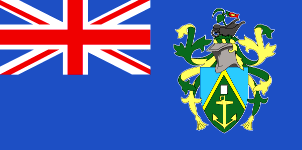
id
Pays
Pays en Anglais
Pitcairn Islands
Pays
Pitcairn Islands
countryucasefr
PITCAIRN ISLANDS
Pays en Chinois
Pays en Espagnol
Isla De Pitcairn
Pays en Italien
Isola Di Pitcairn
Pays en Portugais
Console De Pitcairn
Pays en Allemand
Insel Pitcairn
countryfull
Pitcairn Islands
countrynm
Pitcairn Islands
ISO2
PN
ISO3
PCN
countrycodeisono
612
countrycodeirs
PC
countrycodeirsfr
PC
countrycodeirsmixt
PC
♀Féminin
12
6
51
75
currency
dollar
currencyisocode
NZD
currencyisocodefull
NZD 554
currencypxcode
GBP
currencysymbol
NZ$
currencysubdivision
100 cents
currencyregime
float
currencyvalue
0.6966
Capitale
Adamstown
capitalfr
Adamstown
Superficie km2
47
arealand
47
coastline
51
timezonedeltabegin
-8
flaglink
maplink
pitcairn.gif
outlinemaplink
pn.gif
visapassenger
-1
largestcity
Adamstown
rankpopulation
230
Population
48
rankincome
222
nationalevent
Birthday of Queen ELIZABETH II
nationaleventfr
Anniversaire de la Reine ELIZABETH II
nationalholiday
Second Saturday in June (1926)
Date de naissance aaaa-mm-jj
1926-06-01 00:00:00
3
3
location
Oceania, islands in the South Pacific Ocean, about midway between Peru and New Zealand
terrain
rugged volcanic formation; rocky coastline with cliffs
naturalresources
miro trees (used for handicrafts), fish (manganese
9
rgbback
16777215
todate
1
50
id
Pays
Pays en Anglais
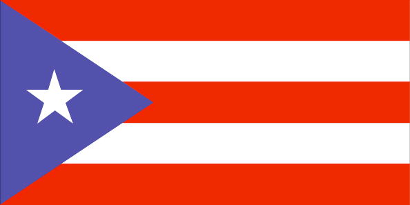
Puerto Rico
Pays
Porto Rico
countryucasefr
PORTO RICO
Pays en Chinois
Pays en Espagnol
Puerto Rico
Pays en Italien
Puerto Rico
Pays en Portugais
Puerto Rico
Pays en Allemand
Puerto Rico
countrypy
bo1 duo1 li2 ge4
countrylocal
Puerto Rico
countryfull
Puerto Rico
countrynm
Puerto Rico
ISO2
PR
ISO3
PRI
countrycodeisono
630
countrycodeolympic
PUR
countrycodeirs
RQ
countrycodeirsfr
RQ
countrycodeirsmixt
RQ
countrycode
1809
12
6
131
languagesfr
Espagnol
6
currency
dollar
currencyfr
dollar
currencyisocode
USD
currencyisocodefull
USD 840
currencypxcode
USD
currencysymbol
$
currencysubdivision
100 cents
currencyregime
float
currencyvalue
1
nationalityfr
Porto Ricaine
Capitale
San Juan
capitalfr
San Juan
Préfixe Tél.
1-787
Superficie km2
9 104
arealand
8 959
areawater
145
landarablerate
0.0372
landforestrate
0.258
coastline
501
summit
Cerro de Punta 1 338 m.
timezonedeltabegin
-4
flaglink
maplink
prcolor.gif
outlinemaplink
pr.gif
visapassenger
-1
maincities
Bayamón, Ponce, Carolina, Caguas, Mayagüez, Arecibo, Guaynabo, Toa Baja, Trujillo, Aguadilla, Cayey, Guayama.
largestcity
San Juan
largestcitypopulation
1 988 584
rankpopulation
124
Population
3 898 000
rankgdp
49
gdp
67897000000
rankgdpppp
56
gdpppp
95613000000
rankgni
55
gni
42057000000
rankincomeorigin
52
rankincome
54
income
10950
rankincomeppp
52
incomeppp
16210
lifeexpectation
77.26
alphabetizationrate
0.891
natalityrate
0.015
mortalityrate
0.00768
mortalityrateinfantile
0.00938
nationalevent
US Independence Day
nationaleventfr
Jour de l'Indépendance
nationalholiday
4 July (1776)
Date de naissance aaaa-mm-jj
1776-07-04 00:00:00
3
9
location
Caribbean, island between the Caribbean Sea and the North Atlantic Ocean, east of the Dominican Republic
terrain
mostly mountains, with coastal plain belt in north; mountains precipitous to sea on west coast; sandy beaches along most coastal areas
naturalresources
some copper and nickel; potential for onshore and
9
Web
rgbback
16777215
todate
1
| Pays/Territoires | Régions en Chine | Provinces de Chine | Régions en France | Départements de France | Provinces du Monde | Villes/Villages | Localités | Continents du Monde | Vins AOP
